Don Pedro Project
The First Don Pedro Reservoir
In 1923, Turlock and Modesto Irrigation Districts joined forces to build the first Don Pedro Dam, which had a storage capacity of 289,000 acre feet. The dam held just enough water to accommodate growers’ irrigation needs for a single growing season. To get through consecutive dry years, which happens often in TID territory, the District needed a dam large enough to store enough water for the demands of multiple irrigation seasons.
Don Pedro Project
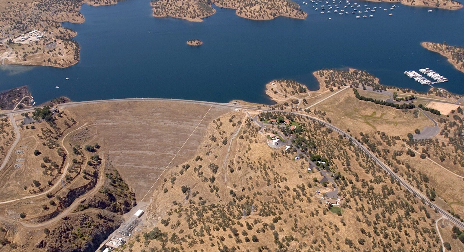
When contemplating a new dam and reservoir project, the Districts were presented with several proposals which they ultimately narrowed to just two different projects. One a “low” concrete arch dam similar to the original Don Pedro but at a height of 485 feet located about a mile and a half downstream of the original dam. The second proposal was for a dam as high as the site would allow. That proposal called for an earth and rockfill dam 580 feet high with a crest length of 1,900 feet requiring 16,400,000 cubic yards of fill material. This new dam would rise to a minimum crest height of 855 feet above sea level and create a reservoir capable of storing 2,030,000 acre feet of water. The Turlock and Modesto Irrigation Districts ultimately decided to build the larger project and New Don Pedro was born. The dam is the ninth highest in the nation and creates the sixth largest artificial lake in the state.
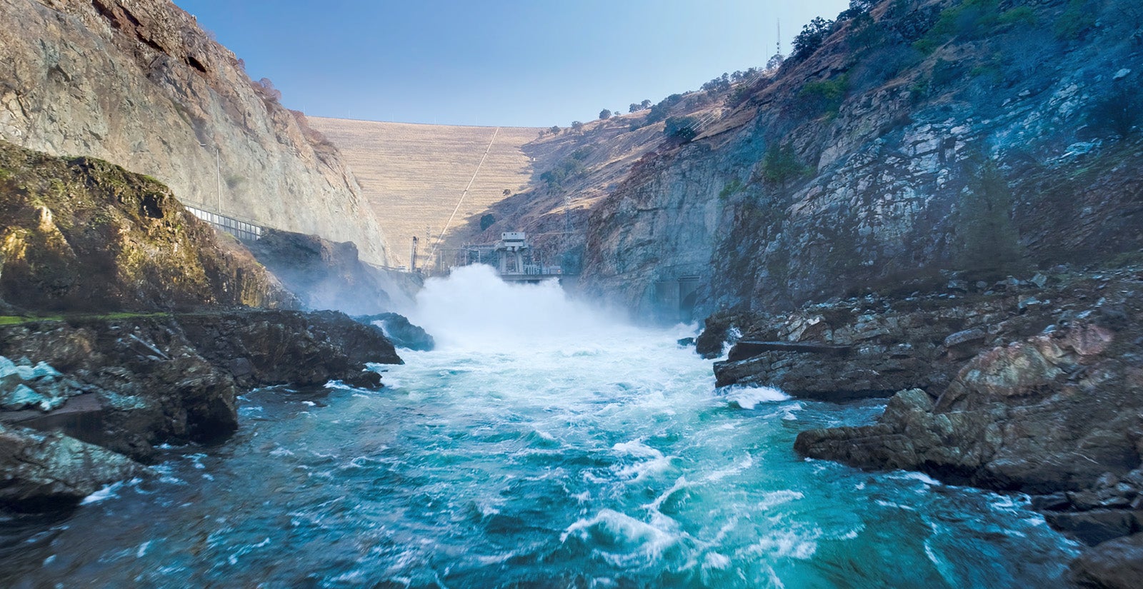
Construction began in 1967 and was completed in 1971. Three smaller earthen embankment dikes (Dikes A, B & C) of similar construction to the main dam also line the reservoir. The spillway, constructed on the right abutment of Dike A, consists of a controlled (gated) spillway with three 45’ wide by 30’ high radial gates and a 995-foot long uncontrolled (auxiliary) spillway. Bonds Flat Road passes below both spillways and connects County Road J59 with recreational facilities at Blue Oaks and Fleming Meadows to Hwy 132.
By constructing the new Don Pedro Dam, power plant and related facilities, the Turlock and Modesto Irrigation Districts firmed up water supplies for their respective districts, increased capacity to generate clean hydroelectric power and provided recreation opportunities and flood control in the Tuolumne River basin.
The City and County of San Francisco joined with the two irrigation districts in constructing the New Don Pedro Project. In exchange for its financial contribution to the construction of the Project, San Francisco obtained relief from upstream flood control responsibility on the Tuolumne River, gained greater flexibility in its upstream operations, but did not receive any physical water storage rights within Don Pedro. This arrangement has proven beneficial to all the parties involved as they cooperate to share a resource by helping to conserve the waters of the Tuolumne and maximize their beneficial use.
Dam
In 1961, an overwhelming majority of voters in the TID and MID(Modesto Irrigation District) service territories along with the City and County of San Francisco, approved bond issues to finance the building of a new dam. Construction was initiated in 1967 and completed in 1971.
With a base thickness of nearly 2,800 feet and rising to a crest width of just 40 feet, Don Pedro Dam is truly an amazing structure. Constructed of an impervious clay core protected by earth and rockfill, most of which was locally sourced from dredge tailings in the river channel near La Grange. Using fifteen cubic yard front-end loaders and a fleet of forty 75-cubic yard bottom dump wagons, contractors hauled 16.4 million yards of dam embankment material 8 miles to the dam site placing approximately 60,000 cubic yards of material each day. In addition to access roads into the remote location, a camp to house the construction crews that ranged between 500 and 700 people was built. Two large bridges were also constructed over arms of the reservoir as part of highway relocations from the reservoir area.
Power Plant
As a public power agency, TID has been delivering power to retail customers since 1923. TID is the majority owner and operator of the reservoir and generation facilities.
Don Pedro’s power plant occupies the entire width of the river channel at the toe of the dam. It’s an outdoor structure, constructed of reinforced concrete and originally contained three 45,500 kilowatt generating units driven by three 70,000 horsepower turbines. In 1989 a fourth unit was added and today; the plant operates three 55,000 kW and one 38,000 kW generators bringing the total capacity of the plant to 203 megawatts with 139 MW going to TID and 64 MW to MID.
Reservoir
When the reservoir is full at 830 feet above sea level, Don Pedro has a capacity of 2,030,000 acre feet, covers 12,960 acres of water surface, extends roughly 26 miles upstream and has approximately 160 miles of shoreline. The reservoir provides 1,381,000 acre feet of active storage space for water supplies and 340,000 acre feet of space to regulate flood flows of the river during the winter season. The minimum pool contains 309,000 acre feet which is 19,000 acre feet more than the original Don Pedro Project held when it was full.
Recreation
Don Pedro Reservoir provides excellent opportunities for fishing, boating, water sports, camping and other related outdoor recreation activities. The reservoir is easily accessible to people from local areas as well as from the large metropolitan areas of Fresno, Sacramento and the San Francisco Bay Area.
Three areas of the reservoir have been developed with funds contributed by the State of California: Fleming Meadows, Blue Oaks and Moccasin Point.
Camping facilities, picnic areas, fish cleaning stations, boat ramps, a swimming lagoon, and marina are among some of the improvements offered at various sites.
Dam Safety
Don Pedro Dam and its critical appurtenant structures are inspected at least:
- Annually by the Federal Energy Regulatory Commission (FERC) and the California Department of Water Resources Division of Safety of Dams (DSOD)
- Quarterly by TID
- As needed by external consultants
In 2017, following the Oroville Spillway Incident, TID performed a focused assessment of the Don Pedro spillway structures. The assessment included a review of the original design and construction documents, detailed inspections and tests, and an analysis of potential failure modes. The assessment was led by qualified external consultants, and involved both FERC and DSOD staff. No safety concerns were identified, and the spillway structures are considered safe for operation.